

Like many other locality names in Malta, Mosta, originally Musta, probably derives from the Arab period. A number of debates about the word origin and meaning have led to various interpretations, the most plausible of which making Musta a derivation of Mwassta, meaning middle-way / at the centre (1) (2)
This would have put Mosta effectively in between the shoreline / sea and the main settlement of Mdina. Moreso, the town is still considered to be generally at the centre of the island even though it is not exactly so.

SPES ALIT RURICOLAM
"Hope strengthens who the land tills" (the farmer)
To read about the origins, history and meaning of Mosta's emblem, please click the image above.
The re-establishment of the Christian Faith by the Normans after their arrival in 1090 AD led to the founding of Malta's first two parishes, at Mdina and in Birgu.
The next three centuries would bring many changes as the Normans gave way to the Swabians, then came the Anjou and eventually the Aragonese until 1530 AD.
Each phase ushered a new host of immigrants forming the roots of modern day Maltese (people) while laying the foundations to many villages that eventually grew into the towns we live in.

Mosta was duly re-assigned from the Mdina Parish to the newly founded Naxxar.
Mosta's population increased gradually, but nearly a century later, it suffered a devastating blow when Sinan Reis, a notorious pirate, raided the town and carried 400 inhabitants away into slavery.
In a report of his Pastoral visit in 1575, Monseigneur Dusina refers to Mosta as a parish, but this status was only officially proclaimed in 1608. This called for the immediate building a new church on the plans drawn by Tommaso Dingli.
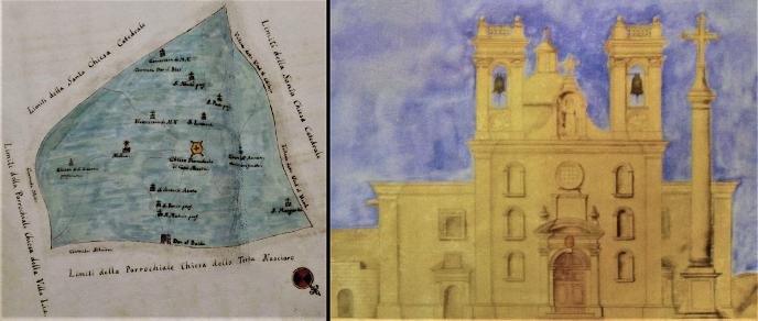


The feast of Saint Mary the Assumption, to whom the church is dedicated, is celebrated annually on the 15th August.
Another well known feature related to popular and religious culture is the Good Friday procession. There are two band clubs and two fireworks factories in Mosta.
All these societies add much life and colour to the various events that dot the socio-parochial year.
There are some 13 other chapels in Mosta, several of which from the late medieval period or the Knight's era (1530-1798). A number of these are situated in the valley itself and have interesting legends tied to their origins.


Speranza & St. Paul the Hermit Chapels in Mosta Valley are both related to legends
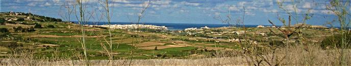
Another of the town's most prominent landmarks is Fort Mosta.
Fort Mosta served as the central hub within a massive defensive structure built during the late 1800s by the British named "The Victoria Lines".
An impressive military and architectural feat enjoying a beautiful wide angle view of the low land that sprawls beyond the geographic fault.
It runs across the width of the island and was fortified by a series of forts and batteries interconnected together with long stretches of defensive walls. This was done to take advantage of the natural fault and to serve as a front line in case of an invasion on the northern coast.


The Dome may be seen as shot from the valley just under the rear side of the fort. The metal bridge was built by the British Army to facilitate access to the fort but was replaced in the early 1980's after it developed structural damage
In the Mosta area the fault is known as Targa with areas overlooking it bearing names such as Targa Gap or San Guzepp tat-Targa, in Mosta and San Pawl tat-Targa in Naxxar.
In English the word Targa, pronounced Tarja, means step.
Fort Mosta is still managed by the military (AFM) as a storage depot for ammunition and explosives. The top part also houses the Police Force Dog Section.
Mosta is also an important hub when it comes to business, commerce and shopping and a large open-air market is present every Monday morning.
The town thrives with many local associations and societies and has its own scouts and girl guides. The historical farmhouse of Marquis Mallia Tabone now houses the Philanthropic Society ‘Talent Mosti’ which is run in collaboration with the adjacent school's council.
To facilitate use of this website, we have added several new indexed pages about the different aspects of our town, packed with interesting photos and information, for all to enjoy.
We are still overhauling our site and thank you for your patience. HPM is a voluntary organisation and our limitations in funds and manpower remain considerable.
If anyone would like to help in any way, kindly contact us through our Facebook Page. We apologise for any inconvenience.

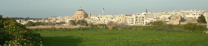
Aerial view of Mosta dated 14.09.2007. Photo taken by Samuele at 18:42
Notes & References:
(1). The Arabic word Wast from the root Wst means at the centre of something or in between two. The verb Wassat means to place at the centre, while placed at the centre becomes Mu Wassat. Hence the old Maltese word Mwassta, which is the feminine form of Mwassat.
(2). It is traditionally believed that although most place names are attributed to the Arab period. Since the islands had been inhabited long before, place names must have already been existent before 870 AD. It has been suggested that many of the Arabic names might be phonetically or practically linked with any such pre-Arabic nomenclature.
Page sources
Storja Tal-Mosta Bil-Knisja Taghha - E.B. Vella et al., 1986
